
Gracias por apoyar a este sitio ❤️
Haz una donación
Haz una donación
Mapa topográfico Chewelah
Haga clic en el mapa para ver la altitud.
Gracias por apoyar a este sitio ❤️
Haz una donación
Haz una donación
Acerca de este mapa
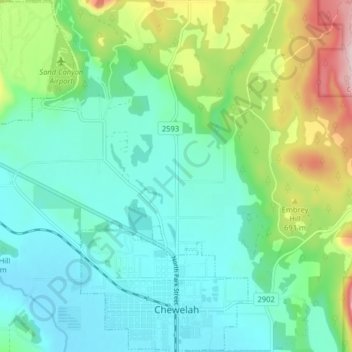
Nombre: Mapa topográfico Chewelah, altitud, relieve.
Lugar: Chewelah, Stevens County, Washington, United States (48.26975 -117.76914 48.32306 -117.69928)
Altitud media: 590 m
Altitud mínima: 497 m
Altitud máxima: 860 m
Gracias por apoyar a este sitio ❤️
Haz una donación
Haz una donación
Otros mapas topográficos
Haga clic en un mapa para ver su topografía, su altitud y su relieve.
Gracias por apoyar a este sitio ❤️
Haz una donación
Haz una donación
Gracias por apoyar a este sitio ❤️
Haz una donación
Haz una donación
Ford
United States > Washington > Stevens County
Ford is located in a mountainous area at the base of Happy Hill, which rises more than 600 feet immediately to the southeast of the community. The northeast–southwest trending Walkers Prairie and valley floor along which Chamokane Creek flows is relatively flat and at an elevation of between 1,700 and 1,800…
Altitud media: 577 m
Gracias por apoyar a este sitio ❤️
Haz una donación
Haz una donación