
Mapa topográfico Waterville
Haga clic en el mapa para ver la altitud.
Waterville
Waterville occupies a high, open position on the Waterville Plateau in central Douglas County, at about 2,622 feet (799 m) above sea level, where the town sits amid broad upland farmland rather than in a river valley. The surrounding terrain is gently rolling to moderately undulating, with shallow draws, low rounded hills such as Standpipe Hill, and subtle local relief rising and falling roughly between 2,450 and 2,860 feet (747–873 m) around the town, while the wider county drops steeply toward the Columbia River and rises higher toward Badger Mountain. This landscape belongs to an elevated plateau framed by the Columbia River system and shaped by Columbia River Basalt bedrock, loess, glacial drift, and Ice Age processes linked to the Cordilleran Ice Sheet, leaving a physical character of dry upland plains, basalt outcrops, glacial erratics, and wheat-growing open country. Overall, Waterville’s topography is spacious and plateau-like: a high agricultural bench with soft relief, long views, and a distinctly inland, semi-arid upland setting above the lower Columbia River valleys.
Acerca de este mapa
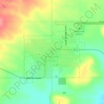
Nombre: Mapa topográfico Waterville, altitud, relieve.
Lugar: Waterville, Douglas County, Washington, United States (47.64053 -120.08250 47.65646 -120.05870)
Altitud media: 807 m
Altitud mínima: 769 m
Altitud máxima: 856 m
Otros mapas topográficos
Haga clic en un mapa para ver su topografía, su altitud y su relieve.
Moses Coulee
United States > Washington > Douglas County
Pleistocene glaciers advanced onto the Waterville Plateau, with the Okanogan Lobe of the Cordilleran Ice Sheet reaching as far south as the town of Withrow. Evidence for glaciation on the Waterville Plateau includes polished and striated bedrock, glacial erratics, drumlinoid topography, eskers, moraines,…
Altitud media: 666 m