
Haz una donación
Mapa topográfico Moses Coulee
Haga clic en el mapa para ver la altitud.
Haz una donación
Moses Coulee
Pleistocene glaciers advanced onto the Waterville Plateau, with the Okanogan Lobe of the Cordilleran Ice Sheet reaching as far south as the town of Withrow. Evidence for glaciation on the Waterville Plateau includes polished and striated bedrock, glacial erratics, drumlinoid topography, eskers, moraines, meltwater channels, and glacial till. The Withrow Moraine complex marks the maximum southern extent of the Okanogan Lobe, and a series of recessional moraine complexes represent retreating ice margins. Ice damming of the Columbia River formed Glacial Lake Columbia and Lake Spokane, larger lakes than Lake Roosevelt, which is currently backed up in the same location behind the Grand Coulee Dam.
Haz una donación
Acerca de este mapa
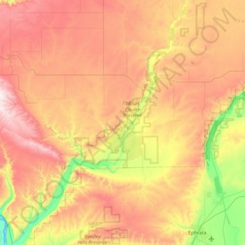
Nombre: Mapa topográfico Moses Coulee, altitud, relieve.
Lugar: Moses Coulee, Douglas County, Washington, United States (47.29413 -120.05919 47.75165 -119.58129)
Altitud media: 666 m
Altitud mínima: 172 m
Altitud máxima: 1.219 m
Haz una donación
Otros mapas topográficos
Haga clic en un mapa para ver su topografía, su altitud y su relieve.
Waterville
United States > Washington > Douglas County
At 2,625 ft (800 m), Waterville has the highest elevation of any incorporated city or town in Washington.
Altitud media: 807 m
Haz una donación
Haz una donación
Haz una donación