
Haz una donación
Mapa topográfico Orondo
Haga clic en el mapa para ver la altitud.
Haz una donación
Acerca de este mapa
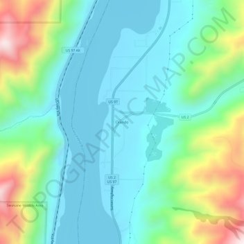
Nombre: Mapa topográfico Orondo, altitud, relieve.
Lugar: Orondo, Douglas County, Washington, United States (47.60554 -120.24581 47.64554 -120.20581)
Altitud media: 386 m
Altitud mínima: 211 m
Altitud máxima: 902 m
Haz una donación
Otros mapas topográficos
Haga clic en un mapa para ver su topografía, su altitud y su relieve.
Waterville
United States > Washington > Douglas County
At 2,625 ft (800 m), Waterville has the highest elevation of any incorporated city or town in Washington.
Altitud media: 807 m
Haz una donación
Moses Coulee
United States > Washington > Douglas County
Pleistocene glaciers advanced onto the Waterville Plateau, with the Okanogan Lobe of the Cordilleran Ice Sheet reaching as far south as the town of Withrow. Evidence for glaciation on the Waterville Plateau includes polished and striated bedrock, glacial erratics, drumlinoid topography, eskers, moraines,…
Altitud media: 666 m