
Mapa topográfico Ringgold
Mapa interactivo
Haga clic en el mapa para ver la altitud.
Acerca de este mapa
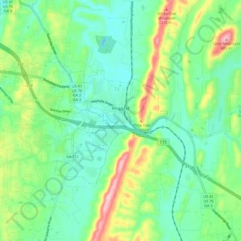
Nombre: Mapa topográfico Ringgold, altitud, relieve.
Lugar: Ringgold, Catoosa County, Georgia, United States (34.88789 -85.19659 34.93480 -85.08769)
Altitud media: 268 m
Altitud mínima: 209 m
Altitud máxima: 407 m
Ringgold is situated in the Valley and Ridge geologic province of the Appalachian Mountains, characterized by long north-northeasterly trending ridges separated by valleys. The topography was formed by the erosion of alternating layers of hard and soft sedimentary rock that were folded and faulted during the building of the Appalachians. Taylor Ridge runs through Ringgold; a gap in the ridge is located just east of the city center, with the part of the ridge running to the south called Taylors Ridge and to the north called White Oak Mountain. South Chickamauga Creek, a tributary of the Tennessee River, runs through Ringgold.
Otros mapas topográficos
Haga clic en un mapa para ver su topografía, su altitud y su relieve.
Boynton
United States > Georgia > Catoosa County
Boynton, Catoosa County, Georgia, 30736, United States
Altitud media: 239 m
Lakeview
United States > Georgia > Catoosa County > Fort Oglethorpe
Lakeview, Fort Oglethorpe, Catoosa County, Georgia, United States
Altitud media: 237 m
Indian Springs
United States > Georgia > Catoosa County
Indian Springs, Catoosa County, Georgia, United States
Altitud media: 236 m
Blue Spring
United States > Georgia > Catoosa County
Blue Spring, Catoosa County, Georgia, United States, Blue Spring Lake
Altitud media: 236 m
Cloud Springs
United States > Georgia > Catoosa County > Fort Oglethorpe
Cloud Springs, Fort Oglethorpe, Catoosa County, Georgia, 30742, United States
Altitud media: 237 m
Fort Oglethorpe
United States > Georgia > Catoosa County
Fort Oglethorpe, Catoosa County, Georgia, 30742, United States
Altitud media: 236 m