
Mapa topográfico Lakeview
Mapa interactivo
Haga clic en el mapa para ver la altitud.
Acerca de este mapa
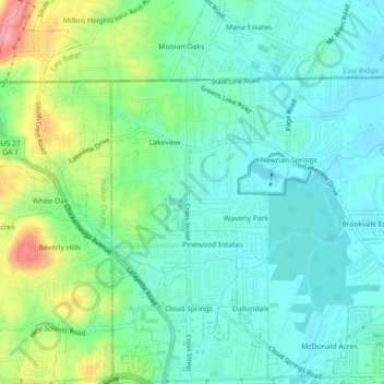
Nombre: Mapa topográfico Lakeview, altitud, relieve.
Altitud media: 237 m
Altitud mínima: 205 m
Altitud máxima: 321 m
Otros mapas topográficos
Haga clic en un mapa para ver su topografía, su altitud y su relieve.
Cloud Springs
United States > Georgia > Catoosa County > Fort Oglethorpe
Cloud Springs, Fort Oglethorpe, Catoosa County, Georgia, 30742, United States
Altitud media: 237 m