
Mapa topográfico Boynton
Mapa interactivo
Haga clic en el mapa para ver la altitud.
Acerca de este mapa
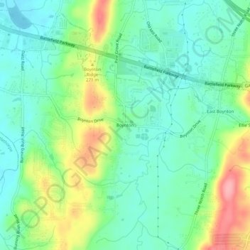
Nombre: Mapa topográfico Boynton, altitud, relieve.
Lugar: Boynton, Catoosa County, Georgia, 30736, United States (34.90341 -85.21079 34.94341 -85.17079)
Altitud media: 239 m
Altitud mínima: 203 m
Altitud máxima: 315 m
Otros mapas topográficos
Haga clic en un mapa para ver su topografía, su altitud y su relieve.
Lakeview
United States > Georgia > Catoosa County > Fort Oglethorpe
Lakeview, Fort Oglethorpe, Catoosa County, Georgia, United States
Altitud media: 237 m
Indian Springs
United States > Georgia > Catoosa County
Indian Springs, Catoosa County, Georgia, United States
Altitud media: 236 m
Ringgold
United States > Georgia > Catoosa County
Ringgold, Catoosa County, Georgia, United States
Altitud media: 268 m
Blue Spring
United States > Georgia > Catoosa County
Blue Spring, Catoosa County, Georgia, United States, Blue Spring Lake
Altitud media: 236 m
Cloud Springs
United States > Georgia > Catoosa County > Fort Oglethorpe
Cloud Springs, Fort Oglethorpe, Catoosa County, Georgia, 30742, United States
Altitud media: 237 m
Fort Oglethorpe
United States > Georgia > Catoosa County
Fort Oglethorpe, Catoosa County, Georgia, 30742, United States
Altitud media: 236 m