
Mapa topográfico Kinshasa
Mapa interactivo
Haga clic en el mapa para ver la altitud.
Acerca de este mapa
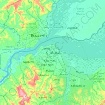
Nombre: Mapa topográfico Kinshasa, altitud, relieve.
Lugar: Kinshasa, Aketi, Kinshasa, Democratic Republic of the Congo (-4.48171 15.15260 -4.16171 15.47260)
Altitud media: 316 m
Altitud mínima: 244 m
Altitud máxima: 641 m
Geographically covering 9,965 square kilometers, Kinshasa stretches along the southern shores of the Pool Malebo, forming an expansive crescent across flat, low-lying terrain at an average altitude of about 300 meters. Situated between latitudes 4° and 5° and longitudes East 15° and 16°32, Kinshasa shares its borders with the Mai-Ndombe Province, Kwilu Province, and Kwango Province to the east; the Congo River delineates its western and northern perimeters, constituting a natural border with the Republic of the Congo; to the south lies the Kongo Central Province. Across the river sits Brazzaville, the smaller capital of the neighboring Republic of the Congo, forming the world's second-closest pair of capital cities despite being separated by a four-kilometer-wide unbridged span of the Congo River.
Otros mapas topográficos
Haga clic en un mapa para ver su topografía, su altitud y su relieve.
Nsele
Democratic Republic of the Congo > Kinshasa
Nsele, Kinshasa, Democratic Republic of the Congo
Altitud media: 431 m
ONL
Democratic Republic of the Congo > Kinshasa
ONL, Kasa-Vubu, Kinshasa, Democratic Republic of the Congo
Altitud media: 293 m
Parc Naturel de la Nsele (Mangiers)
Democratic Republic of the Congo > Kinshasa
Parc Naturel de la Nsele (Mangiers), Nsele, Kinshasa, Democratic Republic of the Congo
Altitud media: 276 m
Amba
Democratic Republic of the Congo > Kinshasa
Amba, Kisenso, Kinshasa, Democratic Republic of the Congo
Altitud media: 353 m
Lemba
Democratic Republic of the Congo > Kinshasa
Lemba, Kinshasa, Democratic Republic of the Congo
Altitud media: 351 m