
Mapa topográfico Nsele
Mapa interactivo
Haga clic en el mapa para ver la altitud.
Acerca de este mapa
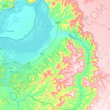
Nombre: Mapa topográfico Nsele, altitud, relieve.
Lugar: Nsele, Kinshasa, Democratic Republic of the Congo (-4.58908 15.34916 -4.11208 15.71545)
Altitud media: 431 m
Altitud mínima: 259 m
Altitud máxima: 725 m
Otros mapas topográficos
Haga clic en un mapa para ver su topografía, su altitud y su relieve.
ONL
Democratic Republic of the Congo > Kinshasa
ONL, Kasa-Vubu, Kinshasa, Democratic Republic of the Congo
Altitud media: 293 m
Parc Naturel de la Nsele (Mangiers)
Democratic Republic of the Congo > Kinshasa
Parc Naturel de la Nsele (Mangiers), Nsele, Kinshasa, Democratic Republic of the Congo
Altitud media: 276 m
Amba
Democratic Republic of the Congo > Kinshasa
Amba, Kisenso, Kinshasa, Democratic Republic of the Congo
Altitud media: 353 m
Kinshasa
Democratic Republic of the Congo > Kinshasa
Kinshasa, Aketi, Kinshasa, Democratic Republic of the Congo
Altitud media: 316 m
Lemba
Democratic Republic of the Congo > Kinshasa
Lemba, Kinshasa, Democratic Republic of the Congo
Altitud media: 351 m