
Mapa topográfico Connecticut
Mapa interactivo
Haga clic en el mapa para ver la altitud.
Acerca de este mapa
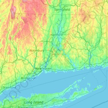
Nombre: Mapa topográfico Connecticut, altitud, relieve.
Lugar: Connecticut, United States (40.95098 -73.72781 42.05058 -71.78724)
Altitud media: 118 m
Altitud mínima: -3 m
Altitud máxima: 780 m
Winters (December through mid-March) are generally cold from south to north in Connecticut. The coldest month (January) has average high temperatures ranging from 38 °F (3 °C) in the coastal lowlands to 33 °F (1 °C) in the inland and northern portions on the state. The lowest temperature recorded in Connecticut is −32 °F (−36 °C) which has been observed twice: in Falls Village on February 16, 1943, and in Coventry on January 22, 1961. The average yearly snowfall ranges from about 60 inches (1,500 mm) in the higher elevations of the northern portion of the state to only 20–25 inches (510–640 mm) along the southeast coast of Connecticut (Branford to Groton). Generally, any locale north or west of Interstate 84 receives the most snow, during a storm, and throughout the season. Most of Connecticut has less than 60 days of snow cover. Snow usually falls from late November to late March in the northern part of the state, and from early December to mid-March in the southern and coastal parts of the state.
Otros mapas topográficos
Haga clic en un mapa para ver su topografía, su altitud y su relieve.
College Station
United States > Texas > Brazos County
College Station, Brazos County, Texas, United States
Altitud media: 87 m
Houston
United States > Texas > Harris County
Houston, Harris County, Texas, United States
Altitud media: 25 m
Sacramento
United States > California > Sacramento County
Sacramento, Sacramento County, California, United States
Altitud media: 10 m
Madison
United States > Wisconsin > Dane County
Madison, Dane County, Wisconsin, United States
Altitud media: 284 m
Spokane
United States > Washington > Spokane County
Spokane, Spokane County, Washington, United States
Altitud media: 655 m
New Orleans
United States > Louisiana > Orleans Parish
New Orleans, Orleans Parish, Louisiana, United States
Altitud media: 1 m
Staten Island
United States > New York > New York
Staten Island, Richmond County, New York, United States
Altitud media: 9 m
Central Park
United States > New York > New York County > New York
Central Park, New York County, New York, United States
Altitud media: 26 m
Boulder
United States > Colorado > Boulder County
Boulder, Boulder County, Colorado, United States
Altitud media: 1.785 m
Texarkana
United States > Texas > Bowie County
Texarkana, Bowie County, Texas, United States
Altitud media: 99 m
Queens County
United States > New York > New York
Queens County, New York, United States
Altitud media: 11 m
Albuquerque
United States > New Mexico > Bernalillo County
Albuquerque, Bernalillo County, New Mexico, United States
Altitud media: 1.688 m
Ruidoso
United States > New Mexico > Lincoln County
Ruidoso, Lincoln County, New Mexico, United States
Altitud media: 2.287 m
Fort Lauderdale
United States > Florida > Broward County
Fort Lauderdale, Broward County, Florida, United States
Altitud media: 5 m
Brooklyn
United States > New York > New York
Brooklyn, Kings County, New York, United States
Altitud media: 9 m