
Mapa topográfico Montana
Mapa interactivo
Haga clic en el mapa para ver la altitud.
Acerca de este mapa
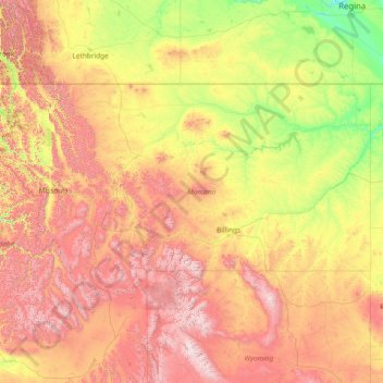
Nombre: Mapa topográfico Montana, altitud, relieve.
Lugar: Montana, United States (44.35792 -116.04923 49.00111 -104.03956)
Altitud media: 1.357 m
Altitud mínima: 552 m
Altitud máxima: 4.034 m
The state's topography is roughly defined by the Continental Divide, which splits much of the state into distinct eastern and western regions. Most of Montana's hundred or more named mountain ranges are in the state's western half, most of which is geologically and geographically part of the northern Rocky Mountains. The Absaroka and Beartooth ranges in the state's south-central part are technically part of the Central Rocky Mountains. The Rocky Mountain Front is a significant feature in the state's north-central portion, and isolated island ranges that interrupt the prairie landscape common in the central and eastern parts of the state. About 60 percent of the state is prairie, part of the northern Great Plains.
Otros mapas topográficos
Haga clic en un mapa para ver su topografía, su altitud y su relieve.
Los Angeles
Los Angeles, Los Angeles County, California, United States
Altitud media: 241 m
Brooklyn
United States > New York > New York
Brooklyn, Kings County, New York, United States
Altitud media: 9 m
Houston
United States > Texas > Harris County
Houston, Harris County, Texas, United States
Altitud media: 25 m
Sarasota
United States > Florida > Sarasota County
Sarasota, Sarasota County, Florida, United States
Altitud media: 7 m
Spokane
United States > Washington > Spokane County
Spokane, Spokane County, Washington, United States
Altitud media: 655 m
Fort Worth
United States > Texas > Tarrant County
Fort Worth, Tarrant County, Texas, United States
Altitud media: 212 m
Appalachian Mountains
United States > North Carolina > Yancey County
Appalachian Mountains, Yancey County, North Carolina, United States
Altitud media: 1.463 m
New Orleans
United States > Louisiana > Orleans Parish
New Orleans, Orleans Parish, Louisiana, United States
Altitud media: 1 m
Jacksonville
United States > Florida > Duval County
Jacksonville, Duval County, Florida, United States
Altitud media: 10 m
City of Albany
United States > New York > Albany County
City of Albany, Albany County, New York, United States
Altitud media: 68 m
Clarksville
United States > Tennessee > Montgomery County
Clarksville, Montgomery County, Middle Tennessee, Tennessee, United States
Altitud media: 155 m
Albuquerque
United States > New Mexico > Bernalillo County
Albuquerque, Bernalillo County, New Mexico, United States
Altitud media: 1.688 m
Boulder
United States > Colorado > Boulder County
Boulder, Boulder County, Colorado, United States
Altitud media: 1.785 m
Fall River
United States > Massachusetts > Bristol County
Fall River, Bristol County, Massachusetts, United States
Altitud media: 32 m
Honolulu
United States > Hawaii > Honolulu County
Honolulu, Honolulu County, Hawaii, United States
Altitud media: 90 m
Knoxville
United States > Tennessee > Knox County
Knoxville, Knox County, East Tennessee, Tennessee, United States
Altitud media: 307 m
Eau Claire County
Eau Claire County, Wisconsin, United States
Altitud media: 304 m