
Mapa topográfico Michigan
Mapa interactivo
Haga clic en el mapa para ver la altitud.
Acerca de este mapa
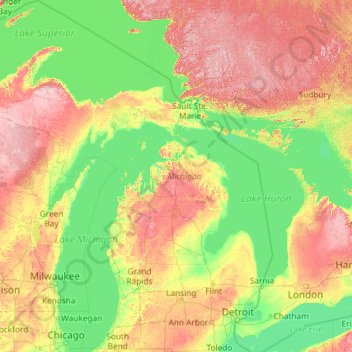
Nombre: Mapa topográfico Michigan, altitud, relieve.
Lugar: Michigan, United States (41.69613 -90.41862 48.30606 -82.12281)
Altitud media: 259 m
Altitud mínima: 169 m
Altitud máxima: 653 m
The heavily forested Upper Peninsula is relatively mountainous in the west. The Porcupine Mountains, which are part of one of the oldest mountain chains in the world, rise to an altitude of almost 2,000 feet (610 m) above sea level and form the watershed between the streams flowing into Lake Superior and Lake Michigan. The surface on either side of this range is rugged. The state's highest point, in the Huron Mountains northwest of Marquette, is Mount Arvon at 1,979 feet (603 m). The peninsula is as large as Connecticut, Delaware, Massachusetts, and Rhode Island combined but has fewer than 330,000 inhabitants. They are sometimes called "Yoopers" (from "U.P.'ers"), and their speech (the "Yooper dialect") has been heavily influenced by the numerous Scandinavian and Canadian immigrants who settled the area during the lumbering and mining boom of the late 19th century.
Otros mapas topográficos
Haga clic en un mapa para ver su topografía, su altitud y su relieve.
Houston
United States > Texas > Harris County
Houston, Harris County, Texas, United States
Altitud media: 25 m
Brooklyn
United States > New York > New York
Brooklyn, Kings County, New York, United States
Altitud media: 9 m
Spokane
United States > Washington > Spokane County
Spokane, Spokane County, Washington, United States
Altitud media: 655 m
Fort Worth
United States > Texas > Tarrant County
Fort Worth, Tarrant County, Texas, United States
Altitud media: 212 m
College Station
United States > Texas > Brazos County
College Station, Brazos County, Texas, United States
Altitud media: 87 m
Hillsborough County
Hillsborough County, Florida, United States
Altitud media: 20 m
Black Hills
United States > South Dakota > Pennington County
Black Hills, Pennington County, South Dakota, United States
Altitud media: 1.894 m
Mount Hood
United States > Oregon > Hood River County
Mount Hood, Hood River County, Oregon, United States
Altitud media: 2.716 m
Chula Vista
United States > California > San Diego County
Chula Vista, San Diego County, California, United States
Altitud media: 42 m
Arlington
United States > Massachusetts > Middlesex County
Arlington, Middlesex County, Massachusetts, United States
Altitud media: 35 m
Delaware County
Delaware County, Pennsylvania, United States
Altitud media: 76 m
Hunterdon County
Hunterdon County, New Jersey, United States
Altitud media: 120 m
Boca Raton
United States > Florida > Palm Beach County > Boca Raton
Boca Raton, Palm Beach County, Florida, 33432, United States
Altitud media: 4 m
Corpus Christi
United States > Texas > Nueces County
Corpus Christi, Nueces County, Texas, United States
Altitud media: 8 m
Lexington
United States > Kentucky > Lexington
Lexington, Fayette County, Kentucky, 40508, United States
Altitud media: 285 m
Seattle
United States > Washington > King County
Seattle, King County, Washington, United States
Altitud media: 40 m
White House
United States > Tennessee > Sumner County > White House
White House, Sumner County, Middle Tennessee, Tennessee, 37188, United States
Altitud media: 254 m
Fernandina Beach
United States > Florida > Nassau County
Fernandina Beach, Nassau County, Florida, 32035, United States
Altitud media: 2 m
Greenwich
United States > Connecticut > Western Connecticut Planning Region
Greenwich, Western Connecticut Planning Region, Connecticut, United States
Altitud media: 57 m