
Mapa topográfico Aconcagua
Mapa interactivo
Haga clic en el mapa para ver la altitud.
Acerca de este mapa
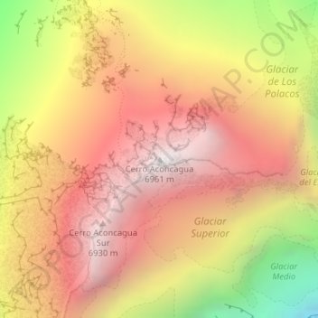
Nombre: Mapa topográfico Aconcagua, altitud, relieve.
Altitud media: 6.201 m
Altitud mínima: 5.031 m
Altitud máxima: 6.947 m
Aconcagua (Spanish pronunciation: [akoŋˈkaɣwa]) is a mountain in the Principal Cordillera of the Andes mountain range, in Mendoza Province, Argentina. It is the highest mountain in the Americas, the highest outside Asia, and the highest in the Southern Hemisphere with a summit elevation of 6,961 metres (22,838 ft). It lies 112 kilometres (70 miles) northwest of the provincial capital, the city of Mendoza, about five kilometres (three miles) from San Juan Province, and 15 km (9 mi) from Argentina's border with neighbouring Chile. The mountain is one of the Seven Summits of the seven continents.
Otros mapas topográficos
Haga clic en un mapa para ver su topografía, su altitud y su relieve.
Andes
Argentina > Mendoza > Distrito Las Cuevas
Andes, Distrito Las Cuevas, Departamento Las Heras, Mendoza, Argentina
Altitud media: 6.208 m
Cerro Aconcagua
Argentina > Mendoza Province > Distrito Las Cuevas
Cerro Aconcagua, Distrito Las Cuevas, Departamento Las Heras, Mendoza Province, Argentina
Altitud media: 6.197 m