
Mapa topográfico Andes
Mapa interactivo
Haga clic en el mapa para ver la altitud.
Acerca de este mapa
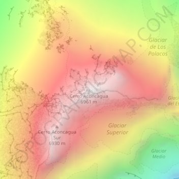
Nombre: Mapa topográfico Andes, altitud, relieve.
Altitud media: 6.208 m
Altitud mínima: 5.053 m
Altitud máxima: 6.947 m
The Andes Mountains are the highest mountain range outside Asia. The highest mountain outside Asia, Argentina's Mount Aconcagua, rises to an elevation of about 6,961 m (22,838 ft) above sea level. The peak of Chimborazo in the Ecuadorian Andes is farther from the Earth's center than any other location on the Earth's surface, due to the equatorial bulge resulting from the Earth's rotation. The world's highest volcanoes are in the Andes, including Ojos del Salado on the Chile-Argentina border, which rises to 6,893 m (22,615 ft).
Otros mapas topográficos
Haga clic en un mapa para ver su topografía, su altitud y su relieve.
Aconcagua
Argentina > Mendoza > Distrito Las Cuevas
Aconcagua, Distrito Las Cuevas, Departamento Las Heras, Mendoza, Argentina
Altitud media: 6.201 m
Cerro Aconcagua
Argentina > Mendoza Province > Distrito Las Cuevas
Cerro Aconcagua, Distrito Las Cuevas, Departamento Las Heras, Mendoza Province, Argentina
Altitud media: 6.197 m