
Mapa topográfico Kasungami
Mapa interactivo
Haga clic en el mapa para ver la altitud.
Acerca de este mapa
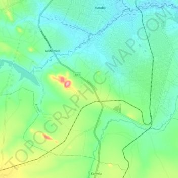
Nombre: Mapa topográfico Kasungami, altitud, relieve.
Altitud media: 1.238 m
Altitud mínima: 1.188 m
Altitud máxima: 1.382 m
Otros mapas topográficos
Haga clic en un mapa para ver su topografía, su altitud y su relieve.
Solola
Democratic Republic of the Congo > Haut-Katanga > Ville de Lubumbashi > Kampemba
Solola, Kampemba, Ville de Lubumbashi, Haut-Katanga, Democratic Republic of the Congo
Altitud media: 1.228 m
Kimbembe
Democratic Republic of the Congo > Haut-Katanga > Ville de Lubumbashi
Kimbembe, Annexe, Ville de Lubumbashi, Haut-Katanga, Democratic Republic of the Congo
Altitud media: 1.261 m
Kasanda
Democratic Republic of the Congo > Haut-Katanga > Ville de Lubumbashi > Matoleo
Kasanda, Matoleo, Ruashi, Ville de Lubumbashi, Haut-Katanga, Democratic Republic of the Congo
Altitud media: 1.303 m
Lubumbashi
Democratic Republic of the Congo > Haut-Katanga > Ville de Lubumbashi
Lubumbashi, Ville de Lubumbashi, Haut-Katanga, Democratic Republic of the Congo
Altitud media: 1.249 m
Météo
Democratic Republic of the Congo > Haut-Katanga > Ville de Lubumbashi > Lubumbashi
Météo, Lubumbashi, Ville de Lubumbashi, Haut-Katanga, Democratic Republic of the Congo
Altitud media: 1.251 m
Bana Katanga
Democratic Republic of the Congo > Haut-Katanga > Ville de Lubumbashi > Bana Katanga
Bana Katanga, Katuba, Ville de Lubumbashi, Haut-Katanga, Democratic Republic of the Congo
Altitud media: 1.201 m
Kundelungu
Democratic Republic of the Congo > Haut-Katanga > Ville de Lubumbashi > Lubumbashi
Kundelungu, Makutano, Lubumbashi, Ville de Lubumbashi, Haut-Katanga, Democratic Republic of the Congo
Altitud media: 1.243 m
Lubumbashi
Democratic Republic of the Congo > Haut-Katanga > Ville de Lubumbashi > Lubumbashi
Lubumbashi, Makutano, Lubumbashi, Ville de Lubumbashi, Haut-Katanga, 13, Democratic Republic of the Congo
Altitud media: 1.259 m
Musumba
Democratic Republic of the Congo > Haut-Katanga > Ville de Lubumbashi
Musumba, Katuba, Ville de Lubumbashi, Haut-Katanga, Democratic Republic of the Congo
Altitud media: 1.207 m