
Mapa topográfico Walsrode
Mapa interactivo
Haga clic en el mapa para ver la altitud.
Acerca de este mapa
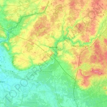
Nombre: Mapa topográfico Walsrode, altitud, relieve.
Lugar: Walsrode, Heidekreis, Lower Saxony, Germany (52.72520 9.37540 52.97042 9.72059)
Altitud media: 48 m
Altitud mínima: 16 m
Altitud máxima: 106 m
Otros mapas topográficos
Haga clic en un mapa para ver su topografía, su altitud y su relieve.
Bad Fallingbostel
Germany > Lower Saxony > Heidekreis
Bad Fallingbostel, Heidekreis, Lower Saxony, 29683, Germany
Altitud media: 64 m
Schülern
Germany > Lower Saxony > Heidekreis > Schneverdingen > Schülern
Schülern, Schneverdingen, Heidekreis, Lower Saxony, 29640, Germany
Altitud media: 80 m
Soltau
Germany > Lower Saxony > Heidekreis > Soltau
Soltau, Heidekreis, Lower Saxony, 29614, Germany
Altitud media: 78 m
Bispingen
Germany > Lower Saxony > Heidekreis
Bispingen, Heidekreis, Lower Saxony, 29646, Germany
Altitud media: 91 m