
Mapa topográfico Bad Fallingbostel
Mapa interactivo
Haga clic en el mapa para ver la altitud.
Acerca de este mapa
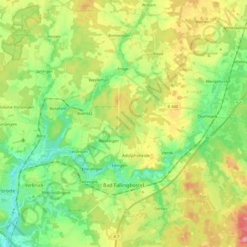
Nombre: Mapa topográfico Bad Fallingbostel, altitud, relieve.
Lugar: Bad Fallingbostel, Heidekreis, Lower Saxony, 29683, Germany (52.83850 9.64492 52.95730 9.86096)
Altitud media: 64 m
Altitud mínima: 27 m
Altitud máxima: 120 m
Otros mapas topográficos
Haga clic en un mapa para ver su topografía, su altitud y su relieve.
Walsrode
Germany > Lower Saxony > Heidekreis
Walsrode, Heidekreis, Lower Saxony, Germany
Altitud media: 48 m
Schülern
Germany > Lower Saxony > Heidekreis > Schneverdingen > Schülern
Schülern, Schneverdingen, Heidekreis, Lower Saxony, 29640, Germany
Altitud media: 80 m
Soltau
Germany > Lower Saxony > Heidekreis > Soltau
Soltau, Heidekreis, Lower Saxony, 29614, Germany
Altitud media: 78 m
Bispingen
Germany > Lower Saxony > Heidekreis
Bispingen, Heidekreis, Lower Saxony, 29646, Germany
Altitud media: 91 m