
Mapa topográfico Tynaarlo
Mapa interactivo
Haga clic en el mapa para ver la altitud.
Acerca de este mapa
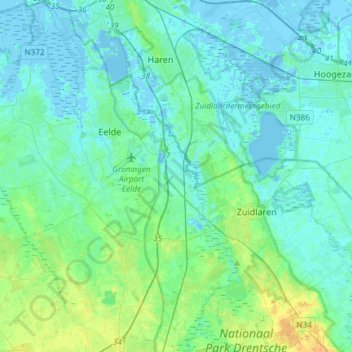
Nombre: Mapa topográfico Tynaarlo, altitud, relieve.
Lugar: Tynaarlo, Drenthe, Netherlands (53.02578 6.48030 53.19831 6.77651)
Altitud media: 5 m
Altitud mínima: -8 m
Altitud máxima: 19 m
Otros mapas topográficos
Haga clic en un mapa para ver su topografía, su altitud y su relieve.
Zuidbarge
Netherlands > Drenthe > Emmen
Zuidbarge, Emmen, Drenthe, Netherlands, 7825 TS, Netherlands
Altitud media: 20 m
Lhee
Lhee, Dwingeloo, Westerveld, Drenthe, Netherlands, 7991 PK, Netherlands
Altitud media: 11 m
Nieuw-Buinen
Nieuw-Buinen, Borger-Odoorn, Drenthe, Netherlands
Altitud media: 7 m