
Mapa topográfico Kolguyev Island
Mapa interactivo
Haga clic en el mapa para ver la altitud.
Acerca de este mapa
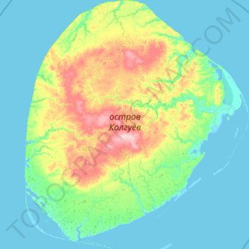
Nombre: Mapa topográfico Kolguyev Island, altitud, relieve.
Altitud media: 26 m
Altitud mínima: -5 m
Altitud máxima: 176 m
The island was explored in 1894 by the British naturalist Aubyn B.R. Trevor-Battye. He landed in June with an assistant, intending to spend about one month studying the wildlife, especially the birds. Due to mechanical problems with the vessel and a misunderstanding, they were left stranded on the island for 12 weeks. He published his study of the natural history and topography of Kolguyev as: "Ice-bound on Kolguev" (Trevor-Battye 1895). The book includes observations on the Nenets (whom he called Samoyed) who brought their reindeer to the island for summer grazing and to trap geese for trade in Russia. Trevor-Battye eventually left the island with these reindeer herders in September 1894, and had to travel 1,000 miles (1,600 km) overland from the Pechora River to Archangel. He described this adventurous journey in: "A northern highway of the Tsar" (Trevor-Battye 1898).
Otros mapas topográficos
Haga clic en un mapa para ver su topografía, su altitud y su relieve.
Vaygach polar station
Russia > Nenets Autonomous Okrug > Zapolyarny District
Vaygach polar station, Zapolyarny District, Nenets Autonomous Okrug, Northwestern Federal District, Russia
Altitud media: 12 m
Vaygach Island
Russia > Nenets Autonomous Okrug
Vaygach Island, Nenets Autonomous Okrug, Northwestern Federal District, Russia
Altitud media: 23 m