
Mapa topográfico Vaygach Island
Mapa interactivo
Haga clic en el mapa para ver la altitud.
Acerca de este mapa
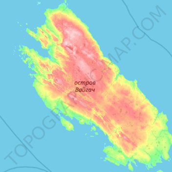
Nombre: Mapa topográfico Vaygach Island, altitud, relieve.
Altitud media: 23 m
Altitud mínima: -1 m
Altitud máxima: 158 m
Vaygach Island is mainly formed of argillaceous slates, sandstone, and limestone. There are many rivers about 20–40 kilometres (12–25 mi) in length, swamps, and small lakes on the island. For the most part it consists of tundra. Slight rocky ridges run generally along its length, and the coast has low cliffs in places. The island consists mostly of limestone, and its elevation above the sea is geologically recent. Raised beaches are frequent. The rocks are heavily scored by ice, but this was probably marine ice, not that of glaciers. The only settlement on the island is Varnek.
Otros mapas topográficos
Haga clic en un mapa para ver su topografía, su altitud y su relieve.
Vaygach polar station
Russia > Nenets Autonomous Okrug > Zapolyarny District
Vaygach polar station, Zapolyarny District, Nenets Autonomous Okrug, Northwestern Federal District, Russia
Altitud media: 12 m
Kolguyev Island
Russia > Nenets Autonomous Okrug
Kolguyev Island, Nenets Autonomous Okrug, Northwestern Federal District, Russia
Altitud media: 26 m