
Haz una donación
Mapa topográfico Cinebar
Haga clic en el mapa para ver la altitud.
Haz una donación
Acerca de este mapa
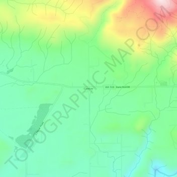
Nombre: Mapa topográfico Cinebar, altitud, relieve.
Lugar: Cinebar, Lewis County, Washington, 98533, United States (46.58427 -122.55178 46.62427 -122.51178)
Altitud media: 308 m
Altitud mínima: 144 m
Altitud máxima: 653 m
Haz una donación
Otros mapas topográficos
Haga clic en un mapa para ver su topografía, su altitud y su relieve.
Haz una donación
Winlock
United States > Washington > Lewis County
The eastern edge of the Willapa Hills lie to the west. To the east are relatively flat prairies. A notable landmark about four miles west of town is Sam Henry Mountain, elevation 1,492 feet (455 m), named for an early section superintendent of the Northern Pacific Railroad. Mt. St. Helens, about forty miles…
Altitud media: 124 m
Haz una donación
Haz una donación
Haz una donación
Napavine
United States > Washington > Lewis County
A railroad depot was built in the late 1910s and provided passenger service until 1960. The Napavine Depot continued to serve the area until the station was permanently closed in April 1968 despite local protest. The Northern Pacific Railway station marked the highest elevation on the line between Portland and…
Altitud media: 105 m