
Gracias por apoyar a este sitio ❤️
Haz una donación
Haz una donación
Mapa topográfico Napavine
Haga clic en el mapa para ver la altitud.
Gracias por apoyar a este sitio ❤️
Haz una donación
Haz una donación
Napavine
A railroad depot was built in the late 1910s and provided passenger service until 1960. The Napavine Depot continued to serve the area until the station was permanently closed in April 1968 despite local protest. The Northern Pacific Railway station marked the highest elevation on the line between Portland and Seattle.
Gracias por apoyar a este sitio ❤️
Haz una donación
Haz una donación
Acerca de este mapa
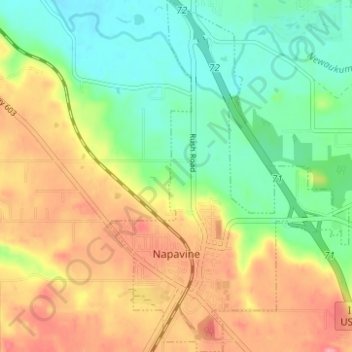
Nombre: Mapa topográfico Napavine, altitud, relieve.
Lugar: Napavine, Lewis County, Washington, 98565, United States (46.56761 -122.92283 46.61029 -122.88077)
Altitud media: 105 m
Altitud mínima: 61 m
Altitud máxima: 162 m
Gracias por apoyar a este sitio ❤️
Haz una donación
Haz una donación
Otros mapas topográficos
Haga clic en un mapa para ver su topografía, su altitud y su relieve.
Gracias por apoyar a este sitio ❤️
Haz una donación
Haz una donación
Gracias por apoyar a este sitio ❤️
Haz una donación
Haz una donación
Gracias por apoyar a este sitio ❤️
Haz una donación
Haz una donación