
Mapa topográfico Mount Marcy
Mapa interactivo
Haga clic en el mapa para ver la altitud.
Acerca de este mapa
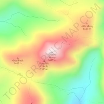
Nombre: Mapa topográfico Mount Marcy, altitud, relieve.
Altitud media: 1.289 m
Altitud mínima: 985 m
Altitud máxima: 1.615 m
Mount Marcy (Mohawk: Tewawe’éstha) is the highest point in New York, with an elevation of 5,343.1 feet (1,628.6 m). It is located in the Town of Keene in Essex County. The mountain is in the heart of the Adirondack High Peaks region of the High Peaks Wilderness Area. Its stature and expansive views make it a popular destination for hikers, who crowd its summit in the summer months.
Otros mapas topográficos
Haga clic en un mapa para ver su topografía, su altitud y su relieve.
Keene Valley
United States > New York > Essex County > Town of Keene
Keene Valley, Town of Keene, Essex County, New York, 12943, United States
Altitud media: 459 m
Saint Huberts
United States > New York > Essex County > Town of Keene
Saint Huberts, Town of Keene, Essex County, New York, 12943, United States
Altitud media: 536 m
Glenmore
United States > New York > Essex County > Town of Keene
Glenmore, Town of Keene, Essex County, New York, 12942, United States
Altitud media: 648 m
Giant Mountain
United States > New York > Essex County > Town of Keene
Giant Mountain, Town of Keene, Essex County, New York, United States
Altitud media: 1.060 m
Gothics
United States > New York > Essex County > Town of Keene
Gothics, Town of Keene, Essex County, New York, United States
Altitud media: 1.095 m