
Mapa topográfico Keene Valley
Mapa interactivo
Haga clic en el mapa para ver la altitud.
Acerca de este mapa
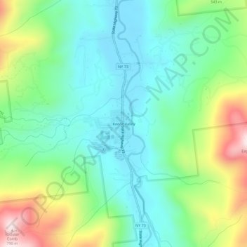
Nombre: Mapa topográfico Keene Valley, altitud, relieve.
Altitud media: 459 m
Altitud mínima: 300 m
Altitud máxima: 825 m
Otros mapas topográficos
Haga clic en un mapa para ver su topografía, su altitud y su relieve.
Saint Huberts
United States > New York > Essex County > Town of Keene
Saint Huberts, Town of Keene, Essex County, New York, 12943, United States
Altitud media: 536 m
Glenmore
United States > New York > Essex County > Town of Keene
Glenmore, Town of Keene, Essex County, New York, 12942, United States
Altitud media: 648 m
Giant Mountain
United States > New York > Essex County > Town of Keene
Giant Mountain, Town of Keene, Essex County, New York, United States
Altitud media: 1.060 m
Gothics
United States > New York > Essex County > Town of Keene
Gothics, Town of Keene, Essex County, New York, United States
Altitud media: 1.095 m
Mount Marcy
United States > New York > Essex County > Town of Keene
Mount Marcy, Town of Keene, Essex County, New York, United States
Altitud media: 1.289 m