
Haz una donación
Mapa topográfico Guarapuava
Haga clic en el mapa para ver la altitud.
Haz una donación
Guarapuava
Guarapuava is located at 25°23'36" S and 51°27'19" W. The region is known as the centre of the state of Paraná, in the third plateau, also called the Plateau of Guarapuava. Discovered by the Portuguese in 1770, and founded in 1810, the city's name derives from tupi guarani, meaning place of Maned wolves sound (Maned wolves are called lobos-guará in Portuguese). Its elevation is 1120 m (3675 ft).
Haz una donación
Acerca de este mapa
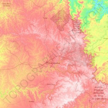
Nombre: Mapa topográfico Guarapuava, altitud, relieve.
Altitud media: 1.001 m
Altitud mínima: 490 m
Altitud máxima: 1.355 m
Haz una donación
Otros mapas topográficos
Haga clic en un mapa para ver su topografía, su altitud y su relieve.
Curitiba
Brazil > Paraná > Região Metropolitana de Curitiba
The city covers 432.17 km2 (166.86 sq mi) on the First Plateau of Paraná. Curitiba has a topography of smooth, rounded hills, giving it a relatively regular shape. The city has an average altitude of 934.6 m (3,066 ft) above sea level. The highest point is to the north at 1,021 m (3,350 ft), and with lower…
Altitud media: 931 m
Haz una donación
Itaipu Dam
Brazil > Paraná > Foz do Iguaçu
325 metres (1,066 ft), entire dam including the 100 metres (330 ft) high Power Line 4 Pylons atop the Barrage 260 metres (850 ft), dam + the foundation inside water until the river floor 247 metres (810 ft), 196 metres (643 ft) high of roof reinforcement concrete dam + Cranes atop the Barrage 225 metres (738…
Altitud media: 192 m
Haz una donación
Curitiba
Brazil > Paraná > Região Metropolitana de Curitiba
The city covers 432.17 km2 (166.86 sq mi) on the First Plateau of Paraná. Curitiba has a topography of smooth, rounded hills, giving it a relatively regular shape. The city has an average altitude of 934.6 m (3,066 ft) above sea level. The highest point is to the north at 1,021 m (3,350 ft), and with lower…
Altitud media: 931 m
Haz una donación
Haz una donación
Tijucas do Sul
Brazil > Paraná > Região Metropolitana de Curitiba > Tijucas do Sul > Tijucas do Sul
Altitud media: 913 m
Haz una donación