
Haz una donación
Mapa topográfico Itaipu Dam
Haga clic en el mapa para ver la altitud.
Haz una donación
Itaipu Dam
325 metres (1,066 ft), entire dam including the 100 metres (330 ft) high Power Line 4 Pylons atop the Barrage 260 metres (850 ft), dam + the foundation inside water until the river floor 247 metres (810 ft), 196 metres (643 ft) high of roof reinforcement concrete dam + Cranes atop the Barrage 225 metres (738 ft), Elevation End Main Concrete Barrage
Haz una donación
Acerca de este mapa
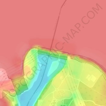
Nombre: Mapa topográfico Itaipu Dam, altitud, relieve.
Altitud media: 192 m
Altitud mínima: 93 m
Altitud máxima: 230 m
Haz una donación
Otros mapas topográficos
Haga clic en un mapa para ver su topografía, su altitud y su relieve.
Itaipu Dam
Brazil > Paraná > Foz do Iguaçu
325 metres (1,066 ft), entire dam including the four 100 metres (330 ft) high Power Line Pylons atop the Barrage 260 metres (850 ft), dam barrage + the foundation inside water until the slope river floor 247 metres (810 ft), 196 metres (643 ft) high of roof reinforcement concrete barrage dam + Cranes atop the…
Altitud media: 203 m