
Mapa topográfico Caltanissetta
Mapa interactivo
Haga clic en el mapa para ver la altitud.
Acerca de este mapa
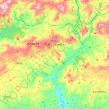
Nombre: Mapa topográfico Caltanissetta, altitud, relieve.
Lugar: Caltanissetta, Sicily, 93100, Italy (37.32933 13.86167 37.59813 14.15923)
Altitud media: 428 m
Altitud mínima: 158 m
Altitud máxima: 849 m
In 2017, the city had a population of 62,797.[4] It is the 14th largest comune in Italy measured by area, the sixth highest comune in Italy by elevation (568 m), the second highest elevation in Sicily after the city of Enna (912 m).
Otros mapas topográficos
Haga clic en un mapa para ver su topografía, su altitud y su relieve.
Bompensiere
Italy > Sicily > Caltanissetta
Bompensiere, Caltanissetta, Sicily, 93010, Italy
Altitud media: 319 m
Mussomeli
Italy > Sicily > Caltanissetta
Mussomeli, Caltanissetta, Sicily, 93014, Italy
Altitud media: 420 m