
Mapa topográfico Bompensiere
Mapa interactivo
Haga clic en el mapa para ver la altitud.
Bompensiere
The town is arranged along a single main street on whose sides the houses are divided, almost uniformly distributed. The lowest point of the town is to the north-west, at an altitude of about 270 meters above sea level (Piana Giarre); the highest point is located in the south-east at an altitude of about 320 meters above sea level (Contrada Portella).
Acerca de este mapa
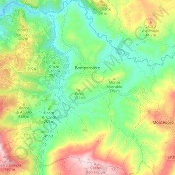
Nombre: Mapa topográfico Bompensiere, altitud, relieve.
Lugar: Bompensiere, Caltanissetta, Sicily, 93010, Italy (37.43393 13.75927 37.49893 13.81269)
Altitud media: 319 m
Altitud mínima: 154 m
Altitud máxima: 583 m