
Mapa topográfico Qumarlêb County
Mapa interactivo
Haga clic en el mapa para ver la altitud.
Acerca de este mapa
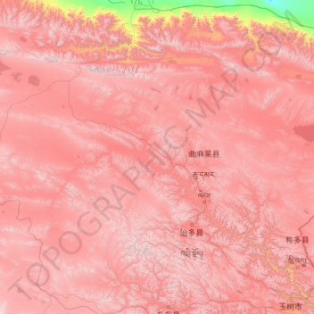
Nombre: Mapa topográfico Qumarlêb County, altitud, relieve.
Altitud media: 4.505 m
Altitud mínima: 2.718 m
Altitud máxima: 5.916 m
With an elevation of around 4,200 metres (14,000 ft), Qumarlêb County has an alpine climate (Köppen ETH), with long, very cold winters, and short, cool and rainy summers. Average low temperatures are below freezing from mid September to late May; however, due to the wide diurnal temperature variation, average highs are only below freezing from mid/late November until early March. Despite frequent rain during summer, when a majority of days sees rain, no month has less than 50 percent of possible sunshine; with monthly percent possible sunshine ranging from 51 percent in June to 78 percent in November, the county seat receives 2,782 hours of bright sunshine annually. The monthly 24-hour average temperature ranges from −14.5 °C (5.9 °F) in January to 8.9 °C (48.0 °F) in July, while the annual mean is −2.13 °C (28.2 °F). Over three-fourths of the annual precipitation of 406 mm (16.0 in) is delivered from June to September.
Otros mapas topográficos
Haga clic en un mapa para ver su topografía, su altitud y su relieve.
Tanggulashan
Tanggulashan, Golmud, Haixi Mongol and Tibetan Autonomous Prefecture, Qinghai, China
Altitud media: 4.756 m
Golmud City
Golmud City, Haixi Mongol and Tibetan Autonomous Prefecture, Qinghai, 816099, China
Altitud media: 4.324 m
Huangnan
China > Qinghai > Tongren City
Huangnan, Tongren City, Huangnan Tibetan Autonomous Prefecture, Qinghai, China
Altitud media: 3.194 m
Golog Tibetan Autonomous Prefecture
China > Qinghai > Gadê County
Golog Tibetan Autonomous Prefecture, Gadê County, Golog Tibetan Autonomous Prefecture, Qinghai, China
Altitud media: 4.340 m
Lamu
China > Qinghai > Hualong Hui Autonomous County
Lamu, Hualong Hui Autonomous County, Haidong, Qinghai, China
Altitud media: 2.256 m
Xireg
China > Qinghai > Ulan County > Xireg
Xireg, Ulan County, Haixi Mongol and Tibetan Autonomous Prefecture, Qinghai, China
Altitud media: 3.248 m
Golog Tibetan Autonomous Prefecture
China > Qinghai > Maqên County > Golog Tibetan Autonomous Prefecture
Golog Tibetan Autonomous Prefecture, Maqên County, Golog Tibetan Autonomous Prefecture, Qinghai, China
Altitud media: 4.148 m
Tanggula Mountains
China > Qinghai > Yanshiping
Tanggula Mountains, Yanshiping, Golmud City, Haixi Mongol and Tibetan Autonomous Prefecture, Qinghai, China
Altitud media: 5.912 m
Yushu Tibetan Autonomous Prefecture
Yushu Tibetan Autonomous Prefecture, Qinghai, China
Altitud media: 4.472 m