
Mapa topográfico Ford City
Mapa interactivo
Haga clic en el mapa para ver la altitud.
Acerca de este mapa
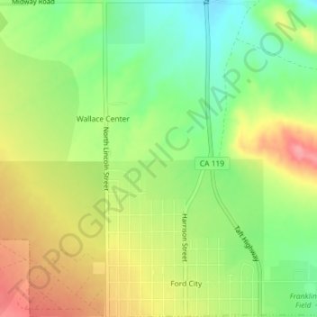
Nombre: Mapa topográfico Ford City, altitud, relieve.
Lugar: Ford City, Taft, Kern County, California, United States (35.15126 -119.46548 35.18064 -119.44785)
Altitud media: 264 m
Altitud mínima: 219 m
Altitud máxima: 314 m
Ford City is a census-designated place (CDP) in Kern County, California, United States. Ford City is located 1 mile (1.61 km) north of Taft, at an elevation of 892 feet (272 m). The population was 4,348 at the 2020 census, up from 4,278 at the 2010 census. It is immediately north of Taft, between the huge Midway-Sunset Oil Field to the southwest, and the almost exhausted Buena Vista Oil Field to the northeast. State Route 119 passes east of town from its junction with SR 33 to the south.
Otros mapas topográficos
Haga clic en un mapa para ver su topografía, su altitud y su relieve.
South Taft
United States > California > Kern County > Taft > South Taft
South Taft, Taft, Kern County, California, United States
Altitud media: 343 m
Taft Heights
United States > California > Kern County > Taft > Taft Heights
Taft Heights, Taft, Kern County, California, United States
Altitud media: 368 m