
Mapa topográfico Saint Petersburg
Mapa interactivo
Haga clic en el mapa para ver la altitud.
Saint Petersburg
The elevation of Saint Petersburg ranges from the sea level to its highest point of 175.9 m (577 ft) at the Orekhovaya Hill in the Duderhof Heights in the south. Part of the city's territory west of Liteyny Prospekt is no higher than 4 m (13 ft) above sea level, and has suffered from numerous floods. Floods in Saint Petersburg are triggered by a long wave in the Baltic Sea, caused by meteorological conditions, winds and shallowness of the Neva Bay. The five most disastrous floods occurred in 1824 (4.21 m or 13 ft 10 in above sea level, during which over 300 buildings were destroyed); 1924 (3.8 m, 12 ft 6 in); 1777 (3.21 m, 10 ft 6 in); 1955 (2.93 m, 9 ft 7 in); and 1975 (2.81 m, 9 ft 3 in). To prevent floods, the Saint Petersburg Dam has been constructed.
Acerca de este mapa
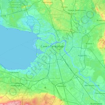
Nombre: Mapa topográfico Saint Petersburg, altitud, relieve.
Lugar: Saint Petersburg, Northwestern Federal District, Russia (59.74415 30.04334 60.09074 30.56717)
Altitud media: 17 m
Altitud mínima: -3 m
Altitud máxima: 118 m
Otros mapas topográficos
Haga clic en un mapa para ver su topografía, su altitud y su relieve.
Saint Petersburg
Russia > Saint Petersburg > Saint Petersburg
The elevation of Saint Petersburg ranges from the sea level to its highest point of 175.9 m (577 ft) at the Orekhovaya Hill in the Duderhof Heights in the south. Part of the city's territory west of Liteyny Prospekt is no higher than 4 m (13 ft) above sea level, and has suffered from numerous floods. Floods in…
Altitud media: 14 m