
Mapa topográfico Saint Petersburg
Mapa interactivo
Haga clic en el mapa para ver la altitud.
Acerca de este mapa
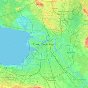
Nombre: Mapa topográfico Saint Petersburg, altitud, relieve.
Altitud media: 14 m
Altitud mínima: -3 m
Altitud máxima: 73 m
The elevation of Saint Petersburg ranges from the sea level to its highest point of 175.9 m (577 ft) at the Orekhovaya Hill in the Duderhof Heights in the south. Part of the city's territory west of Liteyny Prospekt is no higher than 4 m (13 ft) above sea level, and has suffered from numerous floods. Floods in Saint Petersburg are triggered by a long wave in the Baltic Sea, caused by meteorological conditions, winds and shallowness of the Neva Bay. The five most disastrous floods occurred in 1824 (4.21 m or 13 ft 10 in above sea level, during which over 300 buildings were destroyed); 1924 (3.8 m, 12 ft 6 in); 1777 (3.21 m, 10 ft 6 in); 1955 (2.93 m, 9 ft 7 in); and 1975 (2.81 m, 9 ft 3 in). To prevent floods, the Saint Petersburg Dam has been constructed.
Otros mapas topográficos
Haga clic en un mapa para ver su topografía, su altitud y su relieve.
Невский округ
Russia > Saint Petersburg > Saint Petersburg
Невский округ, Saint Petersburg, Northwestern Federal District, Russia
Altitud media: 10 m
Neva River
Russia > Saint Petersburg > Saint Petersburg
Neva River, Saint Petersburg, Northwestern Federal District, 190000, Russia
Altitud media: 25 m
Peter and Paul Fortress
Russia > Saint Petersburg > Saint Petersburg
Peter and Paul Fortress, Западный Артиллерийский мост, Petrograd Side, округ Кронверкское, Saint Petersburg, Northwestern Federal District, 197101, Russia
Altitud media: 7 m