
Mapa topográfico Mount Stuart
Mapa interactivo
Haga clic en el mapa para ver la altitud.
Acerca de este mapa
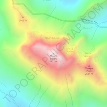
Nombre: Mapa topográfico Mount Stuart, altitud, relieve.
Lugar: Mount Stuart, Chelan County, Washington, United States (47.47510 -120.90204 47.47520 -120.90194)
Altitud media: 2.109 m
Altitud mínima: 1.590 m
Altitud máxima: 2.844 m
Otros mapas topográficos
Haga clic en un mapa para ver su topografía, su altitud y su relieve.
Lake Chelan
United States > Washington > Chelan County > Chelan
Lake Chelan (/ʃəˈlæn/ shə-LAN) is a narrow, 50.5 mi (81.3 km) long lake in Chelan County, north-central Washington state, U.S. It is an overdeepened lake and resembles a fjord, with an average width of 1.3 mi (2.1 km). Near its upper end, the lake surface lies more than 6,600 ft (2,000 m) below peaks less…
Altitud media: 1.358 m
Walla Walla
United States > Washington > Walla Walla County
Walla Walla County features a varied topography characterized by rolling hills, valleys, and river systems. The elevation in the area averages around 940 feet (approximately 287 meters) above sea level, with some areas rising to nearly 1,200 feet. The landscape is shaped by the Walla Walla River, which carves…
Altitud media: 297 m
Vashon Island
United States > Washington > King County > Vashon
Vashon Island features a diverse topography characterized by rolling hills, lush forests, and scenic waterfronts. The island rises gently from sea level to elevations reaching around 500 feet (approximately 150 meters) at its highest point, providing sweeping views of Puget Sound and the surrounding mountains.…
Altitud media: 46 m
Grand Coulee Dam
United States > Washington > Okanogan County
After power shortages in the Northwest during the 1960s, it was determined the six remaining planned pumps be pump-generators. When energy demand is high, the pump-generators can generate electricity with water from the Banks Lake feeder canal adjacent to the dam at a higher elevation. By 1973, the…
Altitud media: 423 m
Town and Country
United States > Washington > Spokane County
The city of Spokane surrounds the CDP on three sides: the east, south and west. The city's street grid continues into Town and Country uninterrupted in the east, though it breaks down in the west along the bluff leading up to Five Mile Prairie. The bulk of the CDP lies on flat ground like the surrounding north…
Altitud media: 639 m
Mount Skokomish Wilderness
United States > Washington > Mason County
Mount Skokomish Wilderness is located in the southeast corner of Olympic National Forest, just north of Lake Cushman. It consists of two long rocky ridges running roughly northeast to southwest. Elevations range from about 2,000 feet (609.6 m) to 6,434 feet (1,961.1 m) at the peak of Mount Skokomish on the…
Altitud media: 1.058 m
Colfax
United States > Washington > Whitman County
Colfax is located in southeastern Washington at 46°53′3″N 117°21′49″W / 46.88417°N 117.36361°W / 46.88417; -117.36361 (46.884033, -117.363668), at an elevation of 1,962 feet (598 m). The nearest cities are Spokane, Pullman, Moscow, and Lewiston/Clarkston. The area is geologically…
Altitud media: 685 m
Ebey's Landing National Historical Reserve
United States > Washington > Island County
Altitud media: 25 m
Ione
United States > Washington > Pend Oreille County
Ione is situated on the west bank of the Pend Oreille River as it flows north towards Canada. Big Muddy Creek, Little Muddy Creek and Cedar Creek, from south to north, join the river in Ione. State Route 31 passes through town. Ione Bridge, on the southern edge of town, is the only road crossing of the Pend…
Altitud media: 670 m
Chopaka Lake
United States > Washington > Okanogan County
Chopaka Lake is a lake in Okanogan County, Washington. It covers an area of approximately 150 acres (0.6 km2), is over 70 ft (21 m) deep at its deepest point, and is 2,910 ft (886 m) in elevation. The lake's name is that of a legendary Okanogan hunter who was transformed to stone by Coyote. It serves as an…
Altitud media: 1.032 m
Snoqualmie Pass
United States > Washington > Kittitas County
Due to its elevation, Snoqualmie Pass experiences significantly lower temperatures than Seattle, and receives much more precipitation, much of it being snow. Snoqualmie Pass has a humid continental climate (Koppen: Dsb bordering Csb) with cold, very wet and snowy winters, and mild to warm, relatively dry…
Altitud media: 955 m
Colchuck Lake
United States > Washington > Chelan County
Colchuck Lake has an area of approximately 87.8 acres (0.355 km2) and a maximum surface elevation of 5,570 feet above sea level, depending on the fluctuation of the depth of the lake. The lake has a tributary basin of 941 acres (3.81 km2) acres, and an average storage capacity estimated at 1,570 acre-feet.
Altitud media: 1.886 m
Lake Marcel
United States > Washington > King County
Lake Marcel is at an altitude of 295 feet (90 m) above sea level. The lake sits in a bowl at the top of Stillwater Hill on the east side of the Snoqualmie Valley, north of Carnation. It has two main areas of water connected by a channel, and several peninsular features make an extensive shoreline around the…
Altitud media: 110 m
Tekoa
United States > Washington > Whitman County
Tekoa was incorporated in 1889 with just under 300 people at the base of Tekoa Mountain (elevation 2,490 feet), on the extreme eastern end of the Palouse, and to the west of the Benewah Range of Idaho. In 1908 the railroad trestle above the town was built. By 1910 the population had grown to 1,694. Over the…
Altitud media: 792 m
Desert Aire
United States > Washington > Grant County
Desert Aire is a census-designated place (CDP) in Grant County, Washington, United States. Desert Aire's elevation is 560 ft (170 m). The population was 1,626 at the 2010 census, up from 1,124 at the 2000 census.
Altitud media: 177 m
Bell Hill
United States > Washington > Clallam County > Bell Hill
Bell Hill is located in eastern Clallam County and is bordered to the north by the city of Sequim. The community is named for the hill that it sits on, which rises to an elevation of over 1,000 feet (300 m) above sea level, or more than 800 feet (240 m) above the center of Sequim. Bell Hill actually has two…
Altitud media: 139 m