
Gracias por apoyar a este sitio ❤️
Haz una donación
Haz una donación
Mapa topográfico Republic
Haga clic en el mapa para ver la altitud.
Gracias por apoyar a este sitio ❤️
Haz una donación
Haz una donación
Acerca de este mapa
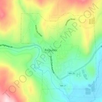
Nombre: Mapa topográfico Republic, altitud, relieve.
Lugar: Republic, Ferry County, Washington, United States (48.63785 -118.74992 48.65798 -118.71961)
Altitud media: 826 m
Altitud mínima: 685 m
Altitud máxima: 1.041 m
Gracias por apoyar a este sitio ❤️
Haz una donación
Haz una donación
Otros mapas topográficos
Haga clic en un mapa para ver su topografía, su altitud y su relieve.
Curlew
United States > Washington > Ferry County
Curlew is located at the confluence of Long Alec Creek and the Kettle River. Its elevation is 1,800 feet (550 m) above sea level. Via State Route 21, it is 21 miles (34 km) north of Republic, the Ferry County seat, and 10 miles (16 km) south of the Canadian border.
Altitud media: 672 m
Gracias por apoyar a este sitio ❤️
Haz una donación
Haz una donación