
Mapa topográfico Adana
Mapa interactivo
Haga clic en el mapa para ver la altitud.
Acerca de este mapa
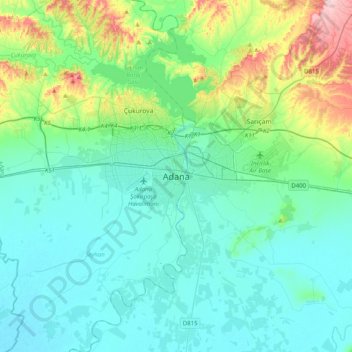
Nombre: Mapa topográfico Adana, altitud, relieve.
Lugar: Adana, Seyhan, Adana, Mediterranean Region, 01010, Turkey (36.82636 35.16529 37.14636 35.48529)
Altitud media: 61 m
Altitud mínima: 3 m
Altitud máxima: 312 m
Heading west across Cilicia from Adana, the path to Tarsus crosses the foothills of the Taurus Mountains, eventually reaching an altitude of nearly 1,200 metres (4,000 ft) while passing through the Cilician Gates (Turkish: Gülek Boğazı), a rocky mountain pass functioning as the main artery to the Turkish hinterland.