
Haz una donación
Mapa topográfico Streat
Haga clic en el mapa para ver la altitud.
Haz una donación
Acerca de este mapa
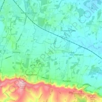
Nombre: Mapa topográfico Streat, altitud, relieve.
Lugar: Streat, Lewes, East Sussex, England, United Kingdom (50.88883 -0.09338 50.95504 -0.06576)
Altitud media: 78 m
Altitud mínima: 23 m
Altitud máxima: 252 m
Haz una donación
Otros mapas topográficos
Haga clic en un mapa para ver su topografía, su altitud y su relieve.
Ditchling Beacon
United Kingdom > England > East Sussex > Lewes
Ditchling Beacon is the highest point in East Sussex, England, with an elevation of 248 m (814 ft). It is south of Ditchling and to the north-east of Brighton. It is a large chalk hill with a particularly steep northern face, covered with open grassland and sheep-grazing areas. It is the third-highest point on…
Altitud media: 144 m
Haz una donación
Haz una donación
Haz una donación
Kingston Near Lewes
United Kingdom > England > East Sussex > Lewes > Kingston Near Lewes
Altitud media: 65 m