
Mapa topográfico Île de Six Milles
Mapa interactivo
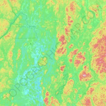
Haga clic en el mapa para ver la altitud.
Acerca de este mapa
Nombre: Mapa topográfico Île de Six Milles, altitud, relieve.
Altitud media: 248 m
Altitud mínima: 138 m
Altitud máxima: 600 m
Otros mapas topográficos
Haga clic en un mapa para ver su topografía, su altitud y su relieve.
Lac du Camp
Canada > Québec > Antoine-Labelle > Notre-Dame-de-Pontmain
Lac du Camp, Notre-Dame-de-Pontmain, Antoine-Labelle, Laurentides, Québec, Canada
Altitud media: 213 m
Lac des Trente et un Milles
Canada > Québec > Antoine-Labelle > Notre-Dame-de-Pontmain
Lac des Trente et un Milles, Notre-Dame-de-Pontmain, Antoine-Labelle, Laurentides, Québec, Canada
Altitud media: 173 m
Lac Babiche
Canada > Québec > Antoine-Labelle > Notre-Dame-de-Pontmain
Lac Babiche, Notre-Dame-de-Pontmain, Antoine-Labelle, Laurentides, Québec, Canada
Altitud media: 346 m