
Mapa topográfico Pullman
Haga clic en el mapa para ver la altitud.
Pullman
Pullman is situated within the Palouse region, characterized by its distinct topography of rolling hills formed from loess deposits—windblown silt accumulated over millennia. The city's average elevation is approximately 2,540 feet (774 meters), with elevations ranging from about 2,342 to 2,575 feet (714 to 785 meters) above sea level. Downtown Pullman lies in a valley bordered by these hills, which rise steeply in certain areas, creating a scenic backdrop. The terrain is notably fertile, ideal for agriculture, particularly the cultivation of winter and spring wheat, barley, and lentils. Additionally, several creeks, including Paradise Creek and Missouri Flat Creek, traverse the landscape, contributing to the region's watershed that eventually feeds into the Snake River and Columbia River systems. The unique geological features and rich soils of the Palouse not only define Pullman's landscape but also play a significant role in its agricultural economy.
Acerca de este mapa
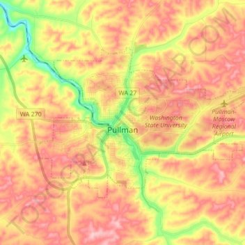
Nombre: Mapa topográfico Pullman, altitud, relieve.
Lugar: Pullman, Whitman County, Washington, United States (46.70453 -117.22207 46.76195 -117.08557)
Altitud media: 774 m
Altitud mínima: 688 m
Altitud máxima: 833 m
Otros mapas topográficos
Haga clic en un mapa para ver su topografía, su altitud y su relieve.
Pullman
United States > Washington > Whitman County > Pullman > Pullman
The city is situated across several loess hills which characterize the Palouse Prairie, formed from windblown sediment over an estimated period of over one million years. This prairie region, the Palouse, is noteworthy for its fertile rolling hills where winter and spring wheat, barley, lentils, and peas are…
Altitud media: 774 m