
Gracias por apoyar a este sitio ❤️
Haz una donación
Haz una donación
Mapa topográfico Serles
Haga clic en el mapa para ver la altitud.
Gracias por apoyar a este sitio ❤️
Haz una donación
Haz una donación
Acerca de este mapa
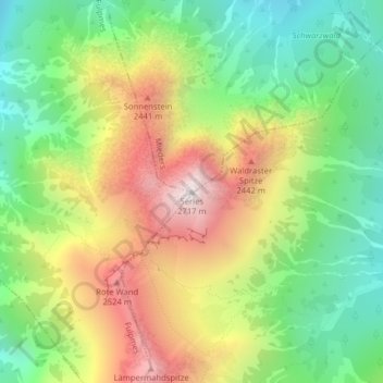
Nombre: Mapa topográfico Serles, altitud, relieve.
Altitud media: 2.036 m
Altitud mínima: 1.558 m
Altitud máxima: 2.685 m
Gracias por apoyar a este sitio ❤️
Haz una donación
Haz una donación
Otros mapas topográficos
Haga clic en un mapa para ver su topografía, su altitud y su relieve.
Stubaital
Österreich > Tirol > Bezirk Innsbruck-Land > Fulpmes
Das Stubaital, kurz das Stubai genannt, ist das größte Seitental des Wipptals und das Haupttal der Stubaier Alpen im österreichischen Bundesland Tirol. Es erstreckt sich vom Alpenhauptkamm 35 km in nordöstlicher Richtung bis in die Nähe der Tiroler Landeshauptstadt Innsbruck. Es ist eine…
Altitud media: 1.547 m