
Mapa topográfico St. Margaret's at Cliffe
Mapa interactivo
Haga clic en el mapa para ver la altitud.
Acerca de este mapa
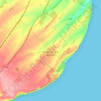
Nombre: Mapa topográfico St. Margaret's at Cliffe, altitud, relieve.
Lugar: St. Margaret's at Cliffe, Dover, Kent, England, United Kingdom (51.13074 1.33161 51.18042 1.40213)
Altitud media: 53 m
Altitud mínima: 0 m
Altitud máxima: 125 m
Otros mapas topográficos
Haga clic en un mapa para ver su topografía, su altitud y su relieve.
White Cliffs of Dover
United Kingdom > England > Kent > Dover > St. Margaret's at Cliffe
White Cliffs of Dover, St. Margaret's at Cliffe, Dover, Kent, England, United Kingdom
Altitud media: 49 m
Sandwich Bay
United Kingdom > England > Kent > Dover
Sandwich Bay, Dover, Kent, England, CT13 9PZ, United Kingdom
Altitud media: 1 m
Claypits
United Kingdom > England > Kent > Dover > Goodnestone
Claypits, Goodnestone, Dover, Kent, England, CT3 1PB, United Kingdom
Altitud media: 34 m
Richborough
United Kingdom > England > Kent > Dover
Richborough, Dover, Kent, England, CT13 9JH, United Kingdom
Altitud media: 4 m
River
United Kingdom > England > Kent > Dover
River, Dover, Kent, England, United Kingdom
Altitud media: 80 m