
Gracias por apoyar a este sitio ❤️
Haz una donación
Haz una donación
Mapa topográfico Goldenstedt
Haga clic en el mapa para ver la altitud.
Gracias por apoyar a este sitio ❤️
Haz una donación
Haz una donación
Goldenstedt
In Ellenstedt existiert ein Windpark. Dort stürzte im Jahr 2002 eine Windkraftanlage mit 70 Metern Nabenhöhe um.
Gracias por apoyar a este sitio ❤️
Haz una donación
Haz una donación
Acerca de este mapa
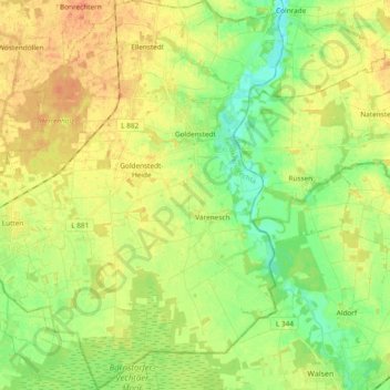
Nombre: Mapa topográfico Goldenstedt, altitud, relieve.
Lugar: Goldenstedt, Landkreis Vechta, Niedersachsen, 49424, Deutschland (52.71223 8.30906 52.82619 8.47367)
Altitud media: 39 m
Altitud mínima: 21 m
Altitud máxima: 57 m
Gracias por apoyar a este sitio ❤️
Haz una donación
Haz una donación
Otros mapas topográficos
Haga clic en un mapa para ver su topografía, su altitud y su relieve.
Gracias por apoyar a este sitio ❤️
Haz una donación
Haz una donación
Gracias por apoyar a este sitio ❤️
Haz una donación
Haz una donación
Severinghausen
Deutschland > Niedersachsen > Landkreis Vechta > Neuenkirchen-Vörden
Altitud media: 59 m
Gracias por apoyar a este sitio ❤️
Haz una donación
Haz una donación
Langenteilen
Deutschland > Niedersachsen > Landkreis Vechta > Damme > Langenteilen
Altitud media: 47 m
Gracias por apoyar a este sitio ❤️
Haz una donación
Haz una donación