
Mapa topográfico Verhniy Ufaley
Mapa interactivo
Haga clic en el mapa para ver la altitud.
Acerca de este mapa
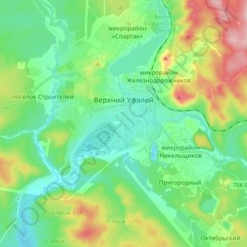
Nombre: Mapa topográfico Verhniy Ufaley, altitud, relieve.
Altitud media: 404 m
Altitud mínima: 347 m
Altitud máxima: 540 m
Lake Itkul, located at the altitude of 720 meters (2,360 ft) above sea level, is one of the notable natural wonders in Verkhny Ufaley. It is fed by springs, creeks, and small rivers, so its waters renew within a year and are fresh and clean. The lake is clear but has a brownish reflection. The lake and its vicinity have become a popular destination for Verkhny Ufaley's residents and visitors alike.