
Mapa topográfico Lac Tarse
Mapa interactivo
Haga clic en el mapa para ver la altitud.
Acerca de este mapa
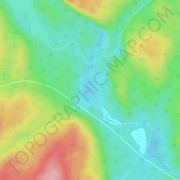
Nombre: Mapa topográfico Lac Tarse, altitud, relieve.
Altitud media: 279 m
Altitud mínima: 225 m
Altitud máxima: 371 m
Otros mapas topográficos
Haga clic en un mapa para ver su topografía, su altitud y su relieve.
Lac Cellier
Canada > Québec > La Vallée-de-la-Gatineau > Lac-Pythonga
Lac Cellier, Lac-Pythonga, La Vallée-de-la-Gatineau, Outaouais, Québec, Canada
Altitud media: 375 m
Lac Grey
Canada > Québec > La Vallée-de-la-Gatineau > Lac-Pythonga
Lac Grey, Lac-Pythonga, La Vallée-de-la-Gatineau, Outaouais, Québec, Canada
Altitud media: 387 m
Lac Bow
Canada > Québec > La Vallée-de-la-Gatineau > Lac-Pythonga
Lac Bow, Lac-Pythonga, La Vallée-de-la-Gatineau, Outaouais, Québec, Canada
Altitud media: 389 m
Lac Chalain
Canada > Québec > La Vallée-de-la-Gatineau > Lac-Pythonga
Lac Chalain, Lac-Pythonga, La Vallée-de-la-Gatineau, Outaouais, Québec, Canada
Altitud media: 384 m