
Mapa topográfico Reuver
Mapa interactivo
Haga clic en el mapa para ver la altitud.
Acerca de este mapa
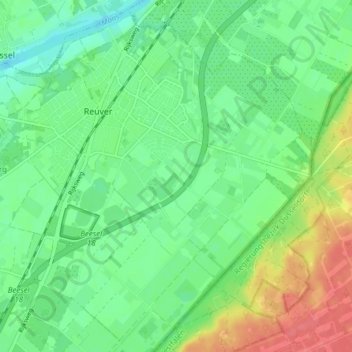
Nombre: Mapa topográfico Reuver, altitud, relieve.
Lugar: Reuver, Beesel, Limburg, Netherlands (51.25215 6.04831 51.29745 6.12476)
Altitud media: 27 m
Altitud mínima: 10 m
Altitud máxima: 64 m
Otros mapas topográficos
Haga clic en un mapa para ver su topografía, su altitud y su relieve.
Helle
Netherlands > Limburg > Mechelen
Helle, Mechelen, Gulpen-Wittem, Limburg, Netherlands, 6281 BS, Netherlands
Altitud media: 158 m
Koningsbosch
Koningsbosch, Echt-Susteren, Limburg, Netherlands
Altitud media: 55 m
Nieuw Bergen
Nieuw Bergen, Bergen, Limburg, Netherlands, 5854 BL, Netherlands
Altitud media: 16 m
Palemig
Netherlands > Limburg > Heerlen
Palemig, Heerlen, Limburg, Netherlands, 6415 RX, Netherlands
Altitud media: 115 m
Heide
Netherlands > Limburg > Susteren
Heide, Susteren, Echt-Susteren, Limburg, Netherlands, 6114 AJ, Netherlands
Altitud media: 32 m
Vrij
Netherlands > Limburg > Siebengewald
Vrij, Siebengewald, Bergen, Limburg, Netherlands, 5853 EJ, Netherlands
Altitud media: 16 m
Kapolder
Netherlands > Limburg > Wijlre
Kapolder, Wijlre, Gulpen-Wittem, Limburg, Netherlands, 6321 PT, Netherlands
Altitud media: 127 m
Maastricht-Airport
Maastricht-Airport, Beek, Limburg, Netherlands
Altitud media: 112 m
Valkenburg
Netherlands > Limburg > Valkenburg
Valkenburg, Limburg, Netherlands, 6301, Netherlands
Altitud media: 121 m
Meuse
Netherlands > Limburg > Maastricht > Borgharen
Meuse, Borgharen, Maastricht, Limburg, Netherlands, 6223 AB, Netherlands
Altitud media: 48 m
Valkenburg
Valkenburg, Valkenburg aan de Geul, Limburg, Netherlands
Altitud media: 123 m
Sint-Pietersberg
Netherlands > Limburg > Maastricht
Sint-Pietersberg, Maastricht, Limburg, Netherlands, 6212NJ, Netherlands
Altitud media: 71 m
Maastricht
Netherlands > Limburg > Maastricht
Maastricht, Limburg, Netherlands, 6211CS, Netherlands
Altitud media: 101 m
Veiligheidsregio Zuid-Limburg
Veiligheidsregio Zuid-Limburg, Limburg, Netherlands
Altitud media: 101 m
Hout-Blerick
Netherlands > Limburg > Venlo
Hout-Blerick, Venlo, Limburg, Netherlands, 5926 RA, Netherlands
Altitud media: 22 m
Eys
Netherlands > Limburg > Eys > Eys
Eys, Gulpen-Wittem, Limburg, Netherlands, 6287, Netherlands
Altitud media: 148 m
Ubachsberg
Netherlands > Limburg > Ubachsberg
Ubachsberg, Voerendaal, Limburg, Netherlands, 6367, Netherlands
Altitud media: 164 m
Holset
Netherlands > Limburg > Holset
Holset, Lemiers, Vaals, Limburg, Netherlands, 6291, Netherlands
Altitud media: 208 m
Limbricht
Netherlands > Limburg > Limbricht
Limbricht, Sittard-Geleen, Limburg, Netherlands
Altitud media: 42 m
Hert
Netherlands > Limburg > Baarlo > Hert
Hert, Baarlo, Peel en Maas, Limburg, Netherlands, 5991, Netherlands
Altitud media: 24 m
Herkenbosch
Netherlands > Limburg > Herkenbosch
Herkenbosch, Roerdalen, Limburg, Netherlands
Altitud media: 38 m
Voulwames
Netherlands > Limburg > Bunde > Voulwames
Voulwames, Bunde, Meerssen, Limburg, Netherlands, 6241NE, Netherlands
Altitud media: 51 m
Panheel
Netherlands > Limburg > Heel > Panheel
Panheel, Heel, Maasgouw, Limburg, Netherlands, 6097, Netherlands
Altitud media: 26 m