
Haz una donación
Mapa topográfico Belterra
Haga clic en el mapa para ver la altitud.
Haz una donación
Belterra
Belterra was founded as a rubber plantation, after the economic failure of Fordlândia, which had been founded in 1928 by Henry Ford. The intention of the US-Department of Commerce in the 1920s was to produce rubber in Brazil and to import it to USA. The advantage of the Belterra plantation over the plantation of Fordlândia 100 km (62 mi) to the south is the flat topography, which enables the use of machinery. In its peak time in the late 1930s some 50 km2 (19 sq mi) were cultivated with Hevea brasiliensis (rubber tree).
Haz una donación
Acerca de este mapa
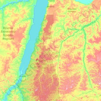
Nombre: Mapa topográfico Belterra, altitud, relieve.
Altitud media: 107 m
Altitud mínima: -2 m
Altitud máxima: 316 m
Haz una donación
Otros mapas topográficos
Haga clic en un mapa para ver su topografía, su altitud y su relieve.
Amazon River
During what many archaeologists called the formative stage, Amazonian societies were deeply involved in the emergence of South America's highland agrarian systems. The trade with Andean civilizations in the terrains of the headwaters in the Andes formed an essential contribution to the social and religious…
Altitud media: 4 m
Amazon River
During what many archaeologists called the formative stage, Amazonian societies were deeply involved in the emergence of South America's highland agrarian systems. The trade with Andean civilizations in the terrains of the headwaters in the Andes formed an essential contribution to the social and religious…
Altitud media: 9 m
Haz una donación
Amazon River
During what many archaeologists called the formative stage, Amazonian societies were deeply involved in the emergence of South America's highland agrarian systems. The trade with Andean civilizations in the terrains of the headwaters in the Andes formed an essential contribution to the social and religious…
Altitud media: 19 m
Haz una donación
Amazon River
During what many archaeologists called the formative stage, Amazonian societies were deeply involved in the emergence of South America's highland agrarian systems. The trade with Andean civilizations in the terrains of the headwaters in the Andes formed an essential contribution to the social and religious…
Altitud media: 5 m
Haz una donación