
Mapa topográfico Allersberg
Mapa interactivo
Haga clic en el mapa para ver la altitud.
Acerca de este mapa
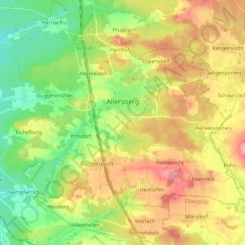
Nombre: Mapa topográfico Allersberg, altitud, relieve.
Lugar: Allersberg, Landkreis Roth, Beieren, 90584, Duitsland (49.20257 11.16195 49.28196 11.32229)
Altitud media: 406 m
Altitud mínima: 349 m
Altitud máxima: 478 m
Otros mapas topográficos
Haga clic en un mapa para ver su topografía, su altitud y su relieve.
Greding
Duitsland > Beieren > Landkreis Roth > Greding
Greding, Landkreis Roth, Beieren, 91171, Duitsland
Altitud media: 488 m
Enderndorf am See
Duitsland > Beieren > Landkreis Roth > Spalt > Enderndorf am See
Enderndorf am See, Spalt, Landkreis Roth, Beieren, 91174, Duitsland
Altitud media: 442 m