
Haz una donación
Mapa topográfico Osterhofen
Haga clic en el mapa para ver la altitud.
Haz una donación
Acerca de este mapa
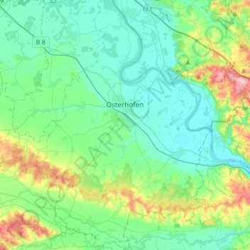
Nombre: Mapa topográfico Osterhofen, altitud, relieve.
Lugar: Osterhofen, Landkreis Deggendorf, Bayern, 94486, Deutschland (48.59822 12.90433 48.77587 13.10105)
Altitud media: 341 m
Altitud mínima: 302 m
Altitud máxima: 475 m
Haz una donación
Otros mapas topográficos
Haga clic en un mapa para ver su topografía, su altitud y su relieve.
Haz una donación
Rechter Plattlinger Mühlbach
Deutschland > Bayern > Landkreis Deggendorf > Plattling
Altitud media: 319 m
Haz una donación
Haz una donación
Ernading
Deutschland > Bayern > Landkreis Deggendorf > Grattersdorf > Grattersdorf
Altitud media: 463 m
Haz una donación
Großwalding
Deutschland > Bayern > Landkreis Deggendorf > Deggendorf > Kleinfilling
Altitud media: 420 m
Haz una donación
Haz una donación
Haz una donación
Thannberg
Deutschland > Bayern > Landkreis Deggendorf > Deggendorf > Oberkandelbach
Altitud media: 395 m
Stauffendorf
Deutschland > Bayern > Landkreis Deggendorf > Deggendorf > Rettenbach
Altitud media: 319 m
Haz una donación
Haz una donación
Haz una donación
Haz una donación
Kleineichberg
Deutschland > Bayern > Landkreis Deggendorf > Deggendorf > Eichberg
Altitud media: 384 m
Haz una donación
Haz una donación
Ruselabsatz
Deutschland > Bayern > Landkreis Deggendorf > Schaufling > Ruselabsatz
Altitud media: 759 m
Haz una donación
Kurzenisarhofen
Deutschland > Bayern > Landkreis Deggendorf > Langenisarhofen > Kurzenisarhofen
Altitud media: 320 m
Haz una donación
Haz una donación
Scheidham
Deutschland > Bayern > Landkreis Deggendorf > Deggendorf > Reinprechting
Altitud media: 415 m
Haz una donación
Haz una donación