
Mapa topográfico Sohra (Cherrapunji)
Mapa interactivo
Haga clic en el mapa para ver la altitud.
Acerca de este mapa
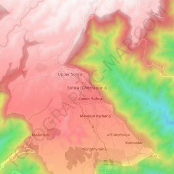
Nombre: Mapa topográfico Sohra (Cherrapunji), altitud, relieve.
Altitud media: 1.169 m
Altitud mínima: 261 m
Altitud máxima: 1.652 m
It has an average elevation of 1,430 metres (4,690 ft) and sits on a plateau in the southern part of the Khasi Hills, facing the plains of Bangladesh. The plateau rises 660 meters above the surrounding valleys.
Otros mapas topográficos
Haga clic en un mapa para ver su topografía, su altitud y su relieve.
Sohsarat
India > Meghalaya > Shella Bholaganj > Nongwar
Sohsarat, Nongwar, Shella Bholaganj, East Khasi Hills District, Meghalaya, India
Altitud media: 372 m
Nongthymmai
India > Meghalaya > Shella Bholaganj
Nongthymmai, Shella Bholaganj, East Khasi Hills District, Meghalaya, 793108, India
Altitud media: 1.123 m
Suktia
India > Meghalaya > Shella Bholaganj
Suktia, Shella Bholaganj, East Khasi Hills, Meghalaya, India
Altitud media: 486 m
Nohsngithiang Falls (Seven Sisters)
India > Meghalaya > Shella Bholaganj
Nohsngithiang Falls (Seven Sisters), Shella Bholaganj, East Khasi Hills, Meghalaya, 793108, India
Altitud media: 1.043 m
Nohkalikai Falls View Point
India > Meghalaya > Shella Bholaganj
Nohkalikai Falls View Point, Root bridge, Shella Bholaganj, East Khasi Hills, Meghalaya, 793108, India
Altitud media: 1.156 m