
Haz una donación
Mapa topográfico Mountlake Terrace
Haga clic en el mapa para ver la altitud.
Haz una donación
Mountlake Terrace
The city sits on a plateau that is elevated from the surrounding landscape, with views of the Olympic and Cascade mountains. The Mountlake Terrace's elevation ranges from 263 to 528 feet (80 to 161 m) above sea level, with an average altitude of 440 feet (130 m). The southwestern portion of the city includes the 100-acre (40 ha) Lake Ballinger, which is fed by Hall Creek from Lynnwood and discharges into McAleer Creek towards Lake Washington. Other portions of Mountlake Terrace lie in the watersheds of Lyon Creek and Swamp Creek, which both drain into Lake Washington.
Haz una donación
Acerca de este mapa
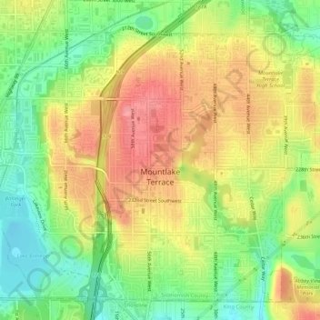
Nombre: Mapa topográfico Mountlake Terrace, altitud, relieve.
Altitud media: 121 m
Altitud mínima: 77 m
Altitud máxima: 162 m
Haz una donación
Otros mapas topográficos
Haga clic en un mapa para ver su topografía, su altitud y su relieve.
Haz una donación
Glacier Peak
United States > Washington > Snohomish County
Despite its elevation of 10,541 feet (3,213 m), Glacier Peak is a small stratovolcano. Its relatively high summit is a consequence of its location atop a high ridge, but its volcanic portion extends only 1,600–3,200 feet (500–1,000 m) above the underlying ridge. Another Cascade Arc volcano with similar…
Altitud media: 2.656 m
Haz una donación
Bridal Veil Falls-Lower East Cascade
United States > Washington > Snohomish County
Altitud media: 621 m
Haz una donación
Whitehorse Mountain
United States > Washington > Snohomish County
Whitehorse Mountain is a peak near the western edge of the North Cascades in Washington state. It is located just southwest of the Sauk River Valley town of Darrington, near the northern boundary of Boulder River Wilderness in Mount Baker-Snoqualmie National Forest. While not of particularly high absolute…
Altitud media: 1.430 m
Haz una donación
Mill Creek
United States > Washington > Snohomish County > Mill Creek > Mill Creek
Altitud media: 129 m
Haz una donación