
Mapa topográfico Badajoz
Mapa interactivo
Haga clic en el mapa para ver la altitud.
Acerca de este mapa
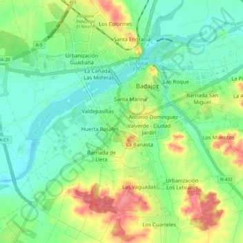
Nombre: Mapa topográfico Badajoz, altitud, relieve.
Lugar: Badajoz, Tierra de Badajoz, Badajoz, Extremadura, Spain (38.83403 -7.01972 38.90019 -6.92491)
Altitud media: 183 m
Altitud mínima: 156 m
Altitud máxima: 234 m
In geological terms, Badajoz is located in the South Submeseta. It was founded on the banks of the Guadiana River on a Paleozoic limestone hill, carved by the river. On this hill is the Alcazaba, one of the main sights of the city. The municipality of Badajoz contains soils derived from tertiary deposits, dating to the Paleozoic era. Its average altitude is 184 metres (604 ft) above sea level. The highest points are located in the Cerro del Viento (219 metres (719 ft)), at Fuerte San Cristóbal (218 metres (715 ft)) and Cerro de la Muela (205 metres (673 ft)). The lowest point is the Guadiana River (168 metres (551 ft)).
Otros mapas topográficos
Haga clic en un mapa para ver su topografía, su altitud y su relieve.
Badajoz
Spain > Extremadura > Tierra de Badajoz
Badajoz, Tierra de Badajoz, Badajoz, Extremadura, Spain
Altitud media: 261 m
La Albuera
Spain > Extremadura > Tierra de Badajoz
La Albuera, Tierra de Badajoz, Badajoz, Extremadura, Spain
Altitud media: 261 m